
Wiggenhall St Peter
|
|
1813 to 1880 Baptism Project Wiggenhall St Peter |
Baptisms 1813 to 1880
|
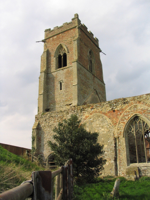
The parish of Wiggenhall St Peter
lies in western Norfolk roughly 5 miles south of the port of
King's Lynn. Norfolk has a group of 4 Wiggenhall parishes each
qualified by the dedication of their church, St Peter parish is
the smallest of the four. Wiggenhall St Peter is located in a
narrow strip of land separating the course of the Great Ouse from
a man-constructed and straighter channel to its east, a strip of
land less than a quarter mile wide by the church, the whole parish
is a little over 2 miles west of the A10 road which connects
King's Lynn through Downham Market and onward to Cambridge. Early
gazetteers show that this was a parish with the farming land
almost equally divided between arable and pastoral farming, the
landscape today is radically different with a mixture of vast
cereal fields with a more intense market gardening on the rich
peaty soils of the Fens. This area is much influenced by man's
drainage schemes and channels, drains and dykes criss-cross the
flat landscape which is barely above sea level for many a mile.
Wiggenhall St Peter parish was small, more reminiscent in size to
a Broadland parish, covering less than 1,000 acres and with a tiny
population to match. |
 |
 |
|
| A single standard 800-entry register book covers the period of this transcript and runs onward to completion in 1929. This register is held by Wisbech & Fenland Museum, a small archive which does not utilise formal archival references. This register was viewed at the Society of Genealogists on Microfilm 1546348 in the collection inherited from the London Family History Centre of the LDS. The imagery was acceptable and a straightforward transcript results. |
Back 1820 1830 1840 1850 1860 1870 1880
Back 1820 1830
1840 1850 1860
1870 1880
Corrections to Tinstaafl
Transcripts