
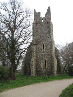
Tunstall St Peter & St Paul
|
|
1813 to 1880 Baptism Project Tunstall St Peter & St Paul |
Baptisms 1813 to 1880
|
The
parish of Tunstall lies in eastern Norfolk about 7 miles west of
the port of Great Yarmouth and just over 2 miles south of Acle.
Tunstall is a small village, little more than a hamlet which sits
on a short ridge of slightly higher land above the grazing marshes
that line the estuary of the Yare, Breydon Water. Tunstall sits
just over a mile south of the busy A47 road which crosses Norfolk
from west to east and which commences its long, straight run
across the grazing marshes within Tunstall parish - the notorious
Acle Straight. The area is dominated by land reclaimed in early
times by man and carries extensive grazing pastures at or even
below sea level at times, the area a maze of drainage channels and
dotted with the iconic wind driven pumps, now largely unused,
which served to keep the water off the land. Besides
pastoral farming income came from reed-thatch harvesting,
wildfowling and water-based transportation. Today Tunstall is a
quiet backwater accessed by a dead-end lane albeit the Weaver's
Way Trail brings a few walkers to the village. |
 |
 |
|
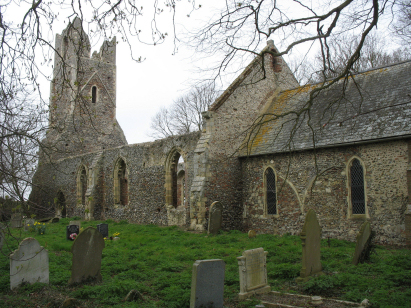
| A single standard 800-entry register book covers not only the period of this transcript but continues on to being surrendered in 1974. This register is filmed on Microfiche 3 in the collection of Norfolk Record Office. The fiche is elderly and poor but better quality imagery is available inline, free to view on Familysearch and for a subcription on the main commercial sites. As a result this transcript was straightforward to prepare. |
Back 1820 1830 1840 1850 1860 1870
Back 1820 1830
1840 1850 1860
1870
Corrections to Tinstaafl
Transcripts