
England
& Wales Hardwicke Marriage Index
Marriages
1754 - 1837
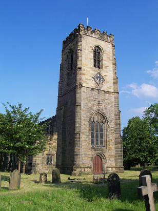
Darton All Saints
| |
England
& Wales Hardwicke Marriage Index |
The ParishThe parish of Darton lies in southwestern Yorkshire, within the West Riding, some 3 1/2 miles northwest of the industrial town of Barnsley. Darton sits on and either side of the A637 road which links Barnsley with Huddersfield. Darton is a village much grown, prior to the industrial revolution it was merely a riverside village on both banks of the River Dearne with subsidiary villages of Barugh, Kexbrough and Mapplewell within the wider parish. The wider parish was extensive farmed with early gazetteers estimating roughly 2:1 in favour of arable over pastoral methods. With the industrial revolution came mining for coal with 3 active pits within the parish, further industrialisation came with nail making, a speciality of Mapplewell, as well as vitriol and bleaching works, the local grit-stone was also extensively quarried for building stone. As a consequence Darton has expanded considerably east of the Dearne engulfing Mapplewell whilst Barugh has also grown to become contiguous with Barnsley. Whilst the mining has finished Ordnance Survey maps still depict the spoil heaps as legacy of the past employment. Modern developments have some in abundance to Darton, the railway line linking Barnsley with both Wakefield and Huddersfield passes through granting Darton a station, in addition the modern M1 motorway cuts a similar pathway along the Dearne's valley linking Sheffield with the north. Darton is drained southwards and then east by the Dearne which passes through Barnsley before meeting the Don at Mexborough, the Don becomes ultimately man-influenced and canalised as it crosses the once Fenland of that portion of the county before joining the other rivers of Yorkshire's Dales to reach the North Sea through the Humber Estuary. Darton is sited on rising sites either side of the Dearne's bridge which stands at 60 metres above the sea, both eastern and western suburbs rise to 110 metres, land rises steadily westwards into the fore-hills of the Pennines reaching a pot height of 269 metres at nearby Hoylandswaine. Darton parish was extensive covering just short of 4,500 acres as are many in the north, this acreage would have supported a population of around 3,600 parishioners, growing markedly during the period of this transcript which indicates a more average population of closer to 2,000. In Domesday times Darton is recorded as mainly "waste", a victim of William's harrowing of the north, a holding with Ilbert de Lacy had managed to re-emerge with a pair of ploughs. |
 |
|
|
|
| Register No | Covering Dates | Deposited With | Register Style | Quality Standard | Comments |
| 1 |
24th May 1754 - 31st December 1812 |
West Yorkshire Archive Service - Wakefield - Reference -
WDP62/1/9 |
Standard preprinted and self-numbered combined Banns &
Marriage register with 4 entries per page |
Grade 2 Register - not a perfect read but with a low
likelihood of misreads |
None |
| 2 | 25th January 1813 - 28th May 1837 | West Yorkshire Archive Service - Wakefield - Reference - WDP62/1/10 | Standard Rose style preprinted and prenumbered Marriage register | Grade 2 Register - not a perfect read but with a low likelihood of
misreads |
None |
|
High
Hoyland All Hallows
|
Woolley
St Peter
Royston St John the Baptist |
Royston
St John the Baptist
|
 |
Royston
St John the Baptist
|
|
|
Silkstone
All Saints
|
Silkstone
All Saints
Barnsley St Mary Barnsley St George
|
1760 1770 1780 1790 1800 1810 1820 1830
Corrections to Tinstaafl Transcripts