
England
& Wales Hardwicke Marriage Index
Marriages
1754 - 1837
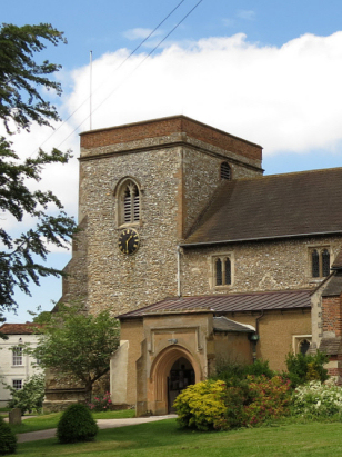
Abbots Langley St Lawrence
| |
England
& Wales Hardwicke Marriage Index |
The ParishThe parish of Abbots Langley lies in southwestern Hertfordshire not too far away from the county's border with neighbouring Buckinghamshire. Abbots Langley is located roughly 4 miles north of the market town of Watford and sits just over 2 miles east of the A41 road which links Watford with Aylesbury. Abbots Langley is a much changed area, early maps show little more than a small village lining today's High Street from just north of St Lawrence's church southwestwards for a half mile or so, that small village being surrounded on all sides by open fields. The only urban development visible at that time was the grounds of the Metropolitan District Asylum to the southeast. Today Abbots Langley has been engulfed within the expansion of Greater London and sits within the M25 orbital motorway as part of a continuous urban fringe that is contiguous through Watford and Harrow to the capital. At the time of this transcript farming still dominated the local economy, cereals were grown but more lucratively was the trade in growing food crops for the metropolis. More industrial was the extensive paper mills that exploited the clear waters of the River Gade with Dickinson's mill being a prominent local employer. Nowadays Abbots Langley sits within a web of modern developments, first to arrive was the Grand Union Canal connecting London with the industrial north and Midlands which followed the Gade valley, taking a similar route the railway line from London to Aylesbury also passes through with neighbouring King's Langley receiving the station for the pair. The modern motorways of the M1, running to Abbots Langley's east, and M25, skirting north and west, encircle the former peaceful rural village. Abbots Langley is drained southwards by the Gade which meets the Colne to the east of Rickmansworth and that in turn the Thames at Staines before that river turns water eastwards passing through the capital to the North Sea. The Gade's valley rises from the river at 65 metres above the sea to the northeastern edges of Abbots Langley at 125 metres, land continues rising only marginally northwards with nearby Bedmond having the highest spot height of 137 metres. Parishes in this area of the county are larger than is normal for southern farming parishes, Abbots Langley parish covered a little over 5,200 acres and would have supported a population of around 2,100 parishioners, it is estimated that the population today exceeds that value by more than 10-fold. In Domesday times Abbots Langley was a holding of nearby St Albans Abbey and a wealthy one even then, it could muster 19 ploughs, meadows and woodland and had a mill presumably along the Gade. |
 |
|
|

|
| Register No | Covering Dates | Deposited With | Register Style | Quality Standard | Comments |
| 1 | 17th July 1754 - 28th December 1812 | Hertfordshire Archives & Local Studies -
Reference - DP/63/1/9 |
Standard preprinted and self-numbered Marriage register with 4 entries per page | Grade 2 Register - not a perfect read but with a low likelihood of misreads | None |
| 2 | 25th February 1813 - 31st May 1837 | Hertfordshire Archives & Local Studies - Reference - DP/63/1/10 | Standard Rose style preprinted and prenumbered Marriage register | Grade 2 Register - not a perfect read but with a low likelihood of misreads | None |
|
Hemel
Hempstead St Mary
|
Hemel
Hempstead St Mary
|
St
Albans St Michael
|
 |
St
Albans St Stephen
Watford St Mary |
|
|
Watford
St Mary
|
Watford
St Mary
|
Watford
St Mary
|
1760 1770 1780 1790 1800 1810 1820 1830
Corrections to Tinstaafl Transcripts