
England
& Wales Hardwicke Marriage Index
Marriages
1754 - 1837
Margam St Mary
| |
England
& Wales Hardwicke Marriage Index |
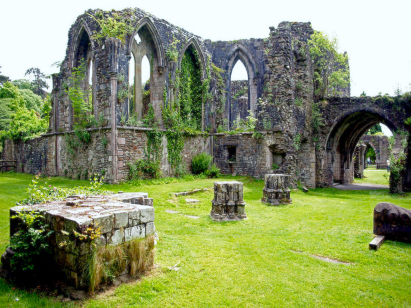
The ParishThe parish of Margam lies on Glamorgan's southern coastline roughly 10 miles southeast of the city of Swansea. Margam sits on the A48 road which links Swansea with Cardiff and is a long stretch of property lying along that road and squeezed in between the Modern M4 motorway and Port Talbot Steel Works, the town forms the southeastern end of a continuous strip of urban developments stretching to the Nedd Estuary. Margam was not always such an industrial town the area has a long history dating back to the Iron Age hill-fort that sits above Margam Abbey on Mynydd y Castell. Margam became a seat of early Christian worship with many early Christian crosses now gathered into its Stones Museum. It was the foundation in 1147 of the Cistercian Abbey which firmly set Margam on the area's map and dominated the economy right up to the Dissolution.Following the Disssolution two families came to domination of Margam, the Mansels followed by the Talbots. All of this early development was around the Abbey site but with exploitation of firstly coal industry came to the area creating today's town on the coastal fringe to the west. The copper smelting business of the area soon developed along with iron works which together saw the population expand considerably. Today Margam sits in the shadow of the perpetually threatened Port Talbot works, closure always being mooted and governments frantically launching survival plans given its importance to the wider economy and employment in the area. The wider parish, and wide it certainly is, covers an extensive area of the hinterland, an area that contains large areas of simple upland grazing by sheep as well as extensive forestry operations especially around Mynydd Margam, the coastal strip was extensively used for growing the hardier cereals prior to being swallowed up beneath serried ranks of terraced properties. Modern developments have come to the area aplenty, the railway line, part of Brunel's Great Western Railway, linking Swansea with Cardiff passes between the town and the steel works but avoids giving Margam a station and more recently the aforementioned and extremely busy M4 motorway carves a path directly beneath the steeply rising slopes of Ergyd Isaf and the town. Drainage to the outer Bristol Channel is largely man-influenced occasioned to avoid flooding of the steel works a series of artificial channels take water to the sea. Margam is sited at just 10 metres above the sea at the A48 with the Abbey site at 40 metres but land rises into the interior of the parish topping out at 349 metres within the forests of Mynydd Margam. Covering over 11,200 acres Margam parish covered much of southern Glamorgan and supported a population of close to 3,500 parishioners. Like most of Wales Margam is not mentioned in Domesday Book which did not cover this area. |
 |
|
|
|
| Register No | Covering Dates | Deposited With | Register Style | Quality Standard | Comments |
| 1 |
11th May 1754 - 11th April 1795 |
Glamorgan Archives - Cardiff - Reference - P83CW/8 |
Standard preprinted and self-numbered combined Banns &
Marriage register with 4 entries per page |
Grade 2 Register - not a perfect read but with a low
likelihood of misreads |
None |
| 2 | 2nd May 1795 - 31st October 1812 | Glamorgan Archives - Cardiff - Reference - P83CW/9 | Standard preprinted and self-numbered Marriage register with 3 entries per page | Grade 2 Register - not a perfect read but with a low likelihood of misreads | None |
| 3 | 10th April 1813 - 24th June 1837 | Glamorgan Archives - Cardiff - Reference - P83CW/10 | Standard Rose style preprinted and prenumbered Marriage register | Grade 1 Register - Few issues noted and a low likelihood of misreads | None |
|
{North_east_contiguous}
|
||
|
Aberavon
St Mary
|
 |
Llangynwyd
St Cynwyd
|
|
|
Pyle
St James
|
Tythegston
St Tydwg
|
1760 1770 1780 1790 1800 1810 1820 1830
Corrections to Tinstaafl Transcripts